This presentation was prompted by a paucity of evidence from existing and free geospatial data in cultural resource management reports and resource forms. Given the deposition context of the Front Range of Colorado where you can find both prehistoric and historic components on the ground surface, CRM archaeologists are missing out on time efficient and defensible data sources for resource documentation. Linear resources especially benefit from a geospatial approach because they're usually often difficult to record in entirety and assess segment contribution to overall resource eligibility to the National Register of Historic Places and a geospatial approach gives the CRM archaeologist basic lines of evidence to generate recommendations based on integrity (NPS Guidelines on Evaluating Integrity).
My goal for this presentation was to give the audience questions to ask of existing geospatial data to inform evaluations of cultural resource integrity and historic significance. The questions increase in specificity from broad (What is my geographic area of interest?) to pointed (Have design, setting, associations changed?) to concurring data (Do multiple sources agree?). I show examples from my own work in Boulder featuring:
- spectral information using multispectral aerial imagery with band indices,
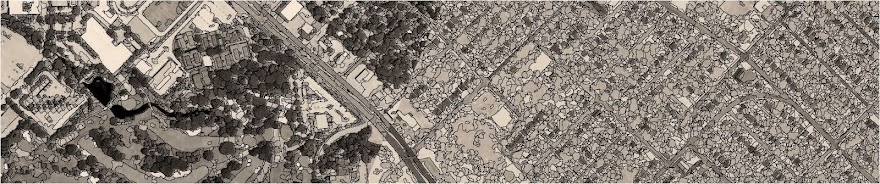
- texture using high spatial resolution panchromatic satellite imagery,
- historic-age maps (from Civilian Conservation Corps in Boulder, 1935),
- LiDAR point clouds,
- LiDAR digital elevation models (DEM),
- LiDAR digital surface models (DSM), and
- change detection using panchromatic historical orthorectified and oblique aerial imagery (partial example below).
Feel free to contact me with questions about the materials. I'm always happy to help people get the most out of their time and money/free data.
-Katy