GPR Basics:
GPR transmitter emits electromagnetic energy into the ground. When the energy encounters a buried object or a boundary between materials having different dielectric constants (also referred to as relative dielectric permittivity), it may be reflected or refracted or scattered back to the surface. A receiving antenna can then record the variations in the return signal. The principles involved are similar to seismology, except that electromagnetic energy is used instead of acoustic energy, and energy may be reflected at boundaries where subsurface electrical properties change rather than subsurface mechanical properties as is the case with seismic energy. The key to detecting features with GPR is that there must be compositional differences between the object, feature, or materials of interest relative to their surrounding media.
GPR transmits electromagnetic pulses from surface antennas into the ground, and then measures the time elapsed between when the pulses are sent and when they are received back at the surface (Conyers and Goodman 1997). Each pulse emitted from the antenna is recorded as an individual trace, which can be referenced as distance or location along a survey transect. So if there's a feature of interest that you see in a radar profile (looking at a cross section of the ground, e.g. not planar map), you can refer to Trace number ____ and use the known length of the transect to figure out the planar location of the feature. Thankfully all GPR data viewing software I know of calculate this for you. Radar travel times (think vertical now) are measured in nanoseconds. So if there's a feature of interest that you see in a radar profile (looking at a cross section of the ground, e.g. not planar map), you can refer to the travel time (___ nanoseconds) and calculate the distance between ground surface and the subsurface feature (using velocity). This is not automatically calculated unless you are able to determine what kind of media the energy is traveling through. If you know the media, you can use known rates of travel (relative dielectric permittivity) to calculate distance from the ground surface. The ability to give each reflection precise depth information is not available in other shallow geophysical methods, which is tremendously useful. GPR surveys allow for a relatively wide aerial coverage in a short period of time, with excellent spatial resolution of buried archaeological features and their related stratigraphy.
Back to radar physics:
Radar waves that move in both the air and the ground are a form of electromagnetic energy composed of cojoined oscillating electrical and magnetic fields. GPR uses high-frequency radio waves (usually polarized) in the range 10 MHz to 1 GHz. These waves are produced when an electric current oscillates back and forth in a conductive body, producing a subsidiary magnetic field. EM waves are then generated that propagate outward from the source. Radar energy used in GPR is produced at an antenna, the simplest of which is a copper wire or plate on which an oscillating electrical current is applied. Depending on the frequency of the oscillation (measured in cycles per second, hertz unit), different wavelengths of propagating radar waves are produced. Different frequency antennas give you different results. Low frequency (~100-200 MHz) and very low frequency (<100 MHz) antennas are suitable for large extent geological or geomorphological features (large scale/low detail). Medium frequency antennas (~200-800 MHz) are suitable for most archaeological applications. Depending on the soils, medium frequency antennas can yield horizontal resolution of as little as 10 cm and vertical resolution as little as 16 cm (in case of dry sand). High frequency antennas (>800 MHz) are suitable for detecting smaller and shallower features where you already know or suspect they are located. The resolution capability increases as center mean frequency of antennas increase; beware of lower depth penetration and shallower attenuation (signal deteriorates into noise) with higher frequency antennas.
The electrical conductivity of the ground, the transmitted center frequency, and the power of the transmitted energy all may limit the effective depth range of GPR investigation. Increases in electrical conductivity attenuate the introduced electromagnetic wave, and thus the penetration depth decreases. Higher frequencies do not penetrate as far as lower frequencies. However, higher frequencies provide improved resolution. Thus operating frequency is always a trade-off between resolution and penetration. Optimal depth of subsurface penetration is achieved in ice where the depth of penetration can achieve several thousand meters (to bedrock in Greenland) at low GPR frequencies. Dry sandy soils or massive dry materials such limestone, and concrete tend to be resistive rather than conductive, and the depth of penetration could be up to 15 meters. In moist and/or clay-laden soils (especially four layer clays like kaolin and smectite groups) and materials with high electrical conductivity, penetration may be as little as a few centimeters.
What is a radar profile or radargram?
As the antennas are moved along the ground surface, individual reflections are recorded about every 2 to 10 centimeters along transects. The form of the individual reflected waves (called a waveform) that are received from within the ground is then digitized into a reflection trace, which is a series of waves reflected back to one surface location. When many traces are stacked next to each other sequentially, a two-dimensional vertical profile is produced along a transect over which the antenna was moved: a GPR reflection profile. This shows how, where, and how much the energy was reflected or traveled through the ground in a cross-section of the ground along a horizontal plane. For archaeologists, think of it as an excavation unit wall: you can see vertical layering and (sometimes) horizons.
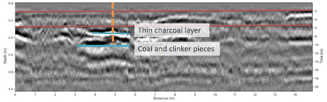
As a GPR practioner, I get nearly all of the information I use for interpretation of GPR data from radar profiles. Profiles give you much more information about the orientation, shape, continuity, and compositional differences of the subsurface materials than an amplitude slice or slice maps.
GPR transmitter emits electromagnetic energy into the ground. When the energy encounters a buried object or a boundary between materials having different dielectric constants (also referred to as relative dielectric permittivity), it may be reflected or refracted or scattered back to the surface. A receiving antenna can then record the variations in the return signal. The principles involved are similar to seismology, except that electromagnetic energy is used instead of acoustic energy, and energy may be reflected at boundaries where subsurface electrical properties change rather than subsurface mechanical properties as is the case with seismic energy. The key to detecting features with GPR is that there must be compositional differences between the object, feature, or materials of interest relative to their surrounding media.
GPR transmits electromagnetic pulses from surface antennas into the ground, and then measures the time elapsed between when the pulses are sent and when they are received back at the surface (Conyers and Goodman 1997). Each pulse emitted from the antenna is recorded as an individual trace, which can be referenced as distance or location along a survey transect. So if there's a feature of interest that you see in a radar profile (looking at a cross section of the ground, e.g. not planar map), you can refer to Trace number ____ and use the known length of the transect to figure out the planar location of the feature. Thankfully all GPR data viewing software I know of calculate this for you. Radar travel times (think vertical now) are measured in nanoseconds. So if there's a feature of interest that you see in a radar profile (looking at a cross section of the ground, e.g. not planar map), you can refer to the travel time (___ nanoseconds) and calculate the distance between ground surface and the subsurface feature (using velocity). This is not automatically calculated unless you are able to determine what kind of media the energy is traveling through. If you know the media, you can use known rates of travel (relative dielectric permittivity) to calculate distance from the ground surface. The ability to give each reflection precise depth information is not available in other shallow geophysical methods, which is tremendously useful. GPR surveys allow for a relatively wide aerial coverage in a short period of time, with excellent spatial resolution of buried archaeological features and their related stratigraphy.
Back to radar physics:
Radar waves that move in both the air and the ground are a form of electromagnetic energy composed of cojoined oscillating electrical and magnetic fields. GPR uses high-frequency radio waves (usually polarized) in the range 10 MHz to 1 GHz. These waves are produced when an electric current oscillates back and forth in a conductive body, producing a subsidiary magnetic field. EM waves are then generated that propagate outward from the source. Radar energy used in GPR is produced at an antenna, the simplest of which is a copper wire or plate on which an oscillating electrical current is applied. Depending on the frequency of the oscillation (measured in cycles per second, hertz unit), different wavelengths of propagating radar waves are produced. Different frequency antennas give you different results. Low frequency (~100-200 MHz) and very low frequency (<100 MHz) antennas are suitable for large extent geological or geomorphological features (large scale/low detail). Medium frequency antennas (~200-800 MHz) are suitable for most archaeological applications. Depending on the soils, medium frequency antennas can yield horizontal resolution of as little as 10 cm and vertical resolution as little as 16 cm (in case of dry sand). High frequency antennas (>800 MHz) are suitable for detecting smaller and shallower features where you already know or suspect they are located. The resolution capability increases as center mean frequency of antennas increase; beware of lower depth penetration and shallower attenuation (signal deteriorates into noise) with higher frequency antennas.
The electrical conductivity of the ground, the transmitted center frequency, and the power of the transmitted energy all may limit the effective depth range of GPR investigation. Increases in electrical conductivity attenuate the introduced electromagnetic wave, and thus the penetration depth decreases. Higher frequencies do not penetrate as far as lower frequencies. However, higher frequencies provide improved resolution. Thus operating frequency is always a trade-off between resolution and penetration. Optimal depth of subsurface penetration is achieved in ice where the depth of penetration can achieve several thousand meters (to bedrock in Greenland) at low GPR frequencies. Dry sandy soils or massive dry materials such limestone, and concrete tend to be resistive rather than conductive, and the depth of penetration could be up to 15 meters. In moist and/or clay-laden soils (especially four layer clays like kaolin and smectite groups) and materials with high electrical conductivity, penetration may be as little as a few centimeters.
What is a radar profile or radargram?
As the antennas are moved along the ground surface, individual reflections are recorded about every 2 to 10 centimeters along transects. The form of the individual reflected waves (called a waveform) that are received from within the ground is then digitized into a reflection trace, which is a series of waves reflected back to one surface location. When many traces are stacked next to each other sequentially, a two-dimensional vertical profile is produced along a transect over which the antenna was moved: a GPR reflection profile. This shows how, where, and how much the energy was reflected or traveled through the ground in a cross-section of the ground along a horizontal plane. For archaeologists, think of it as an excavation unit wall: you can see vertical layering and (sometimes) horizons.

Radar reflection profile from University of Denver Humanities Garden survey (2013)
As a GPR practioner, I get nearly all of the information I use for interpretation of GPR data from radar profiles. Profiles give you much more information about the orientation, shape, continuity, and compositional differences of the subsurface materials than an amplitude slice or slice maps.
What are slice maps?

Amplitude slices at 5 nanosecond increments from Humanities Garden survey (2013); 400 MHz frequency antennas
Think about times when you've seen GPR surveys presented in magazine articles or other publications. Most of those maps used are amplitude slice or slice maps. The maps show horizontal "slices" of the entire survey area from a specific travel time (not necessarily same depth). They typically feature bright or two tone colormaps. The colors represent the amplitude of a trace or waveform at that particular travel time. Amplitude is important as is visualizing the data on a horizontal plane, but amplitudes alone can't be interpreted as features. I will discuss more on waveform amplitude and associated issues at a later date. They are visually attractive and understandably very common in media and publications.
_________________________________________________________________________
Have any questions about ground-penetrating radar in archaeology?
Contact me via the web form below and I will answer as best I can.